


The 7R Future Leadership Institute is following Belgian Floris Buter while he is on a 12 day field trip in Africa, in order to gather topography data for a hydro-power project. The collected data are to be wired to the Belgian engineering firm TPF. They need the data to make a feasibility study.
Since Floris is out there today, the communication depends on the availability of a working internet line, which results in diary fragments coming through in a rather chaotic way.
Today you will find a report of his third day, reaching the site where a hydro power station could be built in the future.
PROJECT DIARY
Topographical Feasibility Study In Hydro-Power Project
Day 3
05:37 I wake up and take a cold shower in hotel Masereka. Fortunately, we bought some fruits, avocado’s and bread yesterday so we can move out early today. We enjoy our improvised breakfast outside the gate around the car before leaving to Alibongo and Kaseghe.
07:24 We arrive at the crossing to Hutwe. We leave the N2 (the second national road in the DRC which is a dirt road) and climb the mountain range East of the N2 and West of Lac Eduard.
07:52 We run into a Mitshubishi Fuso blocking the road. Luckily it doesn’t take long before he clears the road.
08:31 Arrival Hutwe. Hutwe is the town in the middle of the site that we have chosen for our exploration. The canal of the site that we have in mind is running straight through the centre of the village. This means we’ll need to negotiate with the local population before being able to roll out the project. People will have to move and some schools and churches will have to be relocated. We will need to figure this out. Hopefully people will opt for having electricity and a big construction project in the village above opposing to the relocation a few houses and buildings in the area.
09:01 We’re looking for the chef of the village. Every time we arrive in a village in this part of the country we do this. We say hello and explain our mission. Then we show our official mission documents and we will let him put a stamp on it. After this ritual, we usually take some guys that are friends with the chef or the chef himself as a guide for our mission.
This time however, the chef is not there. But his son is. We come to an agreement with the son it is OK for us to be here. The chef knows us because it’s not the first time that we come to visit his post.
09:31 We pick up two guides we know and walk to our first objective: the place where we’re planning to take water from the Taliha Sud river and guide it into a canal. The height of this point is 1818 meters above sea level. We follow the imagined canal for 3,5 km until we reach the point where the water should go down. This place is called the loading chamber. It collects the water from the canal and guides it into the penstock (one to three pipes going down to the power plant).
10:37 We follow the route of the penstock until we get to the place where we picture the powerhouse, 240 meters down, close to the Taliha Sud river. The last time we were here, we were accompanied by Emery and 2 engineers from the Belgian engineering firm TPF. Zébédée measured the flow rates of the 6 sites in the feasibility study in the past.
Since Zébédée is the only topographer to do the job, I am here to show him exactly what piece of land he has to measure to collect the topographical data. This allows us to make a topographic map we will send to TPF to continue the feasibility study.
11:08 We go back up.
12:02 We reach the place where we left Papy and the V08. He’s not there, he was waiting for us on the road near to the loading chamber. He thought we would get straight up. Zébédée calls Papy with the VHF radio. He comes to pick us up.
12:20 As I am the driver, I sometimes misinterpret the road resulting in me banging the landcruiser into a bump in the bizarre and beautiful mountain road.
13:30 We reach the main road. I try to drive just like Papy. After a while Inask asks him whether he thinks my style resembles his. Papy starts laughing and says: “Non, Vous devez suivre la ligne”. I remember we almost drove into a FARDC pick up truck not so long ago. The truck carried six guys sitting on the back wearing camouflage nets on their helmets and big shiny sunglasses. When taking a turn the wrong way we almost hit the truck. I agree with Papy I should have stayed right.
14:57 Kitsombiro. This is one of our favorite snack points on the rod between Kirumba and Lubero ville. We buy young, very young cheese, strawberries and yogurt in Okapi water bottles.
15:20 Katondi. Also a very good snack place. We buy pigs and carrots here.
15:33 We run into Balemba on its way back from Lubero to Rwiindi. He says his boss is going to Butembo.
15:55 We arrive in Lubero. I’m tired from driving, but I want to reach Butembo before dark so I ask Papy to take over, which he gladly does.
16:17 Sheep on the road: dirty and wet.
16:34 We pass the road to Musasa. More than a year ago, on June 13, 2014 to be precise, it was here we tried to reach the Luviro II site before we knew it existed. It was here we took a road that hadn’t been used for more than 4 years. We ended up in a small gold diggers town where they didn’t believe we were looking for hydropower potential in the region. They thought we were gold diggers too. We slept at the “zone de santé” (the medical place, which is a brick empty house without windows at the top of a hill) in our tents after arranging motorbikes to bring us to the site the next morning. We woke up really early and got the hell out of there. There was something wrong with that place.
That same day we found another road that brought us 8 km from the site. The rest we still had to walk. We took the last gps waypoint at 18:00, returned to the car at 20:30 and we were back in Lubero at 22:00. We didn’t know it at that moment but we found 11,6 MW that day. Anyway, that was another day, about one year ago.
17:04 Road blocked by rain. Papy assesses the situation, asks some advice and takes another road up up up. 4×4, a lot of mud 3 meters per minute, smelling engine and rubber parts, mud in my face when I decide to look at the front tire. After 15 minutes of battling the conditions, we make it to the top of the red-brown muddy mountain in a southern suburb of Butembo.
 17:45 We arrive in Butembo.
18:03 Arrival at Hotel Ivatsiro, Butembo center.
18:21 I call Graham, a friend of mine, living in Butembo and working for Texas A&M University. He tells me I am just on time to join him for dinner.
18:25 Cold shower
19:03 Dinner at Graham’s place
19:05 I call Zébédée and tell him that because we finished the Talia Sud site in one day, we’ll take the Sunday of.
19:49 We take motor taxis to ‘l’Auberge’ where we meet Anne, William, Alain, and some other friends. We play the nouns game. Later on we’re doing Karaoke.
23:16 We get into the cars of William and Anne, driving back to town, to a bar, ‘Esebola’, where we drink and dance.
05:05 William drops me at the Ivatsiro Hotel. I sleep.
Notes by Floris Buter
 Floris Buter is the Managing Director Commercial Enterprises of the Virunga National Park in Africa. He is responsible for the identification, conceptualization, implementation and operation of all commercial opportunities in and around Virunga National Park.
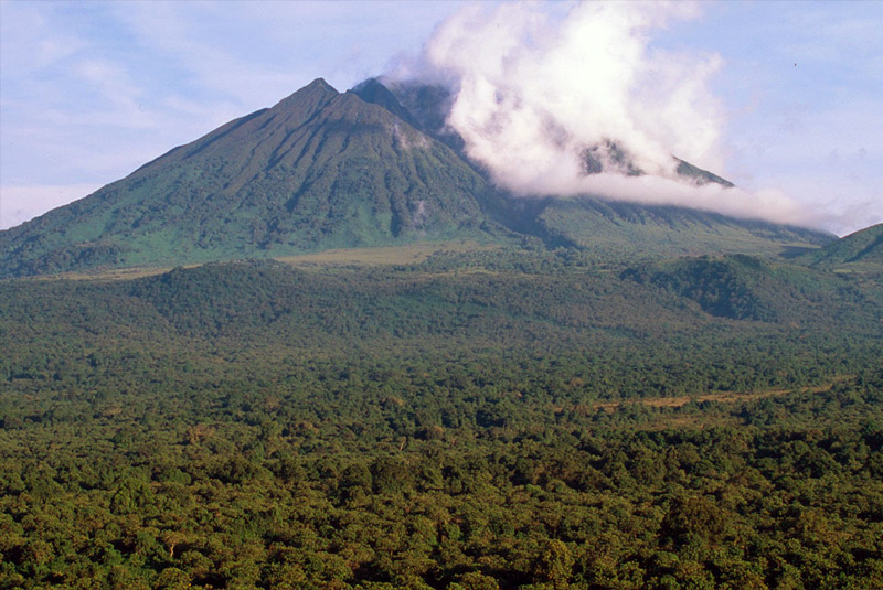
Virunga is truly the crown jewel of Africa’s national parks. The park contains over 50% of sub-Saharan Africa’s biodiversity and is home to about 200 of the earth’s last 720 critically endangered mountain gorillas. Virunga is the oldest national park in the Africa. Despite this, the forests and amazing animals of the park, most notably the mountain gorilla, are in a desperate fight for their survival.
In June 2015 Floris Buter explores the region of Rumungabo in Goma on a 12 day road trip in order to gather topography data for a hydro-power project.
To read the other diary posts from Floris Buter, click here.
Are you a scientist, adventurer or explorer on a mission ?
The 7R Future Leadership Institute supports nature research and exploration. If you are a scientist, adventurer or explorer on a mission, we are interested in your story. Please contact us via info(at)fli.institute to discuss terms and conditions.
Categories: Nature Research, Research, Virunga National Park Research


